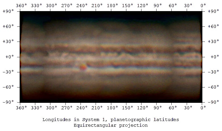
A Full Planetary Map of Jupiter
/For a while I’ve been curious if I can take images of a planet and digitally convert them into a geographic map. I started out trying to write my own software before I realized software called WinJUPOS does it much better than I was ever going to do on my own.
WinJUPOS has a pretty steep learning curve but it’s fascinating software. Essentially, when you take a photo of a planet you tag it with the exact time and location where you took the image and it will line that up with what the planet looked like at that moment. The software then knows what latitude and longitude each pixel of your image should line up with on the planet, a tool within the software can then generate a map for you.
After some experimentation I found one of the hardest things was to ensure that each image was roughly the same brightness and color so I would end up with one continuous map instead of an obvious patchwork of different images. After a lot of small tweaks and adjustments I am thrilled that I have successfully mapped a PLANET!
I ended up using 6 images collected over the course of 5 nights. I was able to use two images from the night that I took a time lapse animation of Jupiter moving because the first and last images were far enough apart to fill in a good portion of the map.
I had a difficult time letting WinJUPOS generate the map with all 6 images together, there were very obvious color and brightness jumps that I didn’t like. I ended up matching the color and brightness the best I could in DarkTable, and then let StarStax combine all 6 images for me. If any images overlapped I had StarStax take the brightest pixel of the overlapping images. This was able to smooth out the hard and abrupt image transitions slightly.
These were the 6 images that were used to create the map:
Each image was taken with my 8 inch dobsonian telescope with 4x barlow lens and ZWO ASI290MC camera. Settings for each image were roughly the same, but definitely not identical. Image capture lengths ranged from 3-4 minutes, which was then stacked in Autostakkert using 15-25% of the frames, and the final sharpening was done using wavelets in Registax. As I mentioned earlier some final saturation and brightness tweaks were made in DarkTable.
Considering this whole thing started off as idle curiosity if this was possible I’m extremely pleased with the results! The final image is relatively low resolution, but you’ll hear no complaints from me!
If I did this again I would be much more careful to use the exact same exposure settings for each image, and save my wavelets sharpening configuration so each image is post-processed identically to one another.
In a totally unnecessary endeavor I can also digitally add this geographic map back onto a spherical shape so we can play with a 3D Jupiter globe.
Now to try Mars…


